May 24, 2025 | 16:26 GMT +7
May 24, 2025 | 16:26 GMT +7
Hotline: 0913.378.918
May 24, 2025 | 16:26 GMT +7
Hotline: 0913.378.918

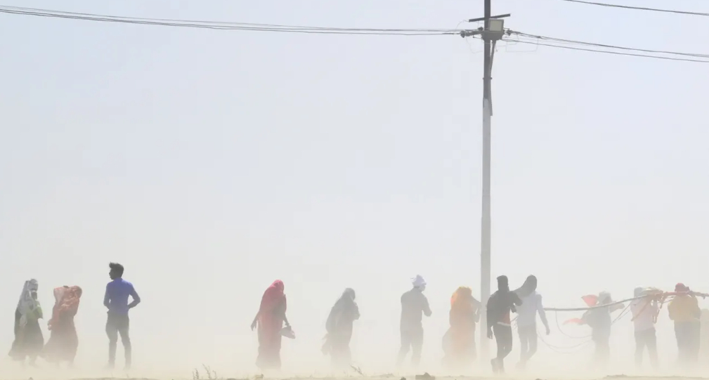
People walk through a dust storm in Prayagraj, India. Countries across the world are experiencing record temperatures. Photograph: Sanjay Kanojia/AFP/Getty Images
“Very unusual”, “worrying”, “terrifying”, and “bonkers”; the reactions of veteran scientists to the sharp increase in north Atlantic surface temperatures over the past three months raises the question of whether the world’s climate has entered a more erratic and dangerous phase with the onset of an El Niño event on top of human-made global heating.
Since April, the warming appears to have entered a new trajectory. Meanwhile the area of global sea ice has dropped by more than 1 million sq km below the previous low.
“If a few decades ago, some people might have thought climate change was a relatively slow-moving phenomenon, we are now witnessing our climate changing at a terrifying rate,” said Prof Peter Stott, who leads the UK Met Office’s climate monitoring and attribution team. “As the El Niño builds through the rest of this year, adding an extra oomph to the damaging effects of human-induced global heating, many millions of people across the planet and many diverse ecosystems are going to face extraordinary challenges and unfortunately suffer great damage.”
The El Niño climate pattern emerges when normal easterly winds weaken and warm water spreads across the whole Pacific.
The immediate impact is on marine life which is unaccustomed to waters that have warmed by several degrees in some areas. More worrying still, the extra energy in the ocean, which is the world’s biggest heat absorber, may bring fiercer-than-usual storms, more destructive rain dumps and longer, hotter heatwaves.
When the extremes in the north Atlantic started to be registered in April, the hope was that this would prove a temporary blip. In May, however, the average temperature in the region was the highest since records began in 1850. On 12 June, the climatologist Brian McNoldy stirred up a Twitter storm by calculating that, based on past data, there was a one in 256,0000 chance of this happening.
This anomaly prompted some commentators to wonder if something unforeseen – a black swan event – was taking place in the climate system. Calmer heads explained that it was more likely the result of El Niño and other natural factors being amplified by the greenhouse gas emissions from cars, factories and forest clearance.
Michael Mann, the presidential distinguished professor at the University of Pennsylvania, warned against “cherry picking” one set of data from one region over a relatively short period of time. It was more important, he said, to focus on the bigger picture: that burning fossil fuels was leading to more powerful and destructive hurricanes as well as providing the energy in the atmosphere to fuel extreme weather events, such as droughts, heatwaves, wildfires, and floods. “We need to step back and look at the big picture. And it is alarming. The truth,” Mann said, “is bad enough.”
Katharine Hayhoe, the chief scientist with the Nature Conservancy and distinguished professor at Texas Tech University, said the north Atlantic temperature anomaly was the result of long-term loading of the climate system by 380 zeta joules of extra heat from human emissions of heat-trapping gases. “Nearly 90% of it has been going into the ocean; and it’s that gradual but inexorable increase in ocean heat content over time scales of decades rather than years that most worries climate scientists,” she said.
Around Ireland and the UK, coastal waters have been several degrees warmer than average for the time of year. Storms are now forming in the Atlantic earlier than normal, almost certainly as a result of the extra energy that is building up in the surface layer of the ocean. For the first time in June, there have been two simultaneous named tropical storms in the Atlantic, Bret and Cindy.
However, rather than seeing the north Atlantic spike as a one-off event, Richard Betts, the head of the climate impacts division at the Met Office’s Hadley Centre in Exeter said: “We can expect this kind of event to happen more often – which of course is a major cause for concern. For me, these graphs [of Atlantic surface temperature and Antarctic sea ice] are like yet another hammer blow driving home the urgency of the climate situation we are now in.”
While human emissions and El Niño are likely to be the two main drivers of the north Atlantic spike, Zeke Hausfather, a climate scientist with the Breakthrough Institute, said more time was needed to disentangle other possible contributing factors, such as this year’s unusual dearth in Saharan dust levels, the large amount of stratospheric water vapour, the slowing of ocean circulation and the increasing frequency of El Niño events.
More broadly, Hausfather said, the trends were in line with climate models from the Intergovernmental Panel on Climate Change (IPCC) that showed warming would accelerate in coming decades unless emissions were reduced. “I’m reluctant to say that it’s worse than we expected, because what we expect in a world where we don’t reduce emissions is bad enough.”
How much worse things get depends on the intensity and duration of this El Niño. Carlos Nobre, who is one of Brazil’s top climate scientists, said there was a 60% chance that this year’s El Niño would be a strong one. This would be “very very worrying” for the Amazon rainforest, which sustained some of its worst degradation during 2015-16, when an El Niño event caused the dry season to become longer and left the vegetation more vulnerable to fire.
Elsewhere in the world, the latest El Niño is already causing misery. In Mexico, several cities have recently broken the record for their hottest days ever, including Chihuahua, Nuevo Laredo and Monclova. Many cities in Texas are sweltering in their worst-ever heatwaves. The same is true in China, where more than 20 cities, including Shandong, Tianjin and Huairou have registered new peaks. In Europe, the Austrian town of Oberndorf sweltered in a freakishly hot midnight temperature of 36.1C, one of the continent’s highest-ever nighttime temperatures. In the Middle East, people are used to heat but they can normally expect some respite at high altitudes. That was not the case in Iran last week, when the temperature in Saravan hit 45C – one of the hottest days ever recorded at an elevation of more than 1,000m.
Many things are still uncertain. Scientists will not know for a couple of months how severe El Niño will be. Its wind-sheering effect could inhibit storm formation and help to balance out the pressure of the sea-level temperature. The north Atlantic heat spike is already showing signs that it may fade.
But there is no doubt among scientists that things will continue to get worse as long as greenhouse gases continue to rise and natural climate stabilisers, such as the Amazon, continue to be cut down.
Hayhoe said the trends made her feel “even more concerned and even more motivated to ensure I’m doing everything I can to help people understand the profound risks climate change poses to them and how each of us can be a powerful advocate for climate action”.
“It makes me feel sad and anxious,” said Stott. “Sad for the level of environmental destruction going on around the world, including the continuing destruction of the Amazon rainforest. And anxious for how people are going to cope if this carries on much longer, not just in far-away places that are already very hot and dry, but here in the UK where fires, flash floods and droughts are getting more and more frequent and intense. It isn’t a secure and sustaining future to look forward to. I still hope a turning point can be reached such that greenhouse gas emissions do start to reduce rapidly. And I know that this can be done without devastating our quality of life, quite the opposite in fact.”
(The Guardian)

(VAN) Alt Carbon has raised $12 million in a seed round as it plans to scale its carbon dioxide removal work in the South Asian nation.

(VAN) Attempts to bring down the price of the Japanese staple have had little effect amid a cost-of-living crisis.

(VAN) Fourth most important food crop in peril as Latin America and Caribbean suffer from slow-onset climate disaster.

(VAN) Shifting market dynamics and the noise around new legislation has propelled Trouw Nutrition’s research around early life nutrition in poultry. Today, it continues to be a key area of research.

(VAN) India is concerned about its food security and the livelihoods of its farmers if more US food imports are allowed.

(VAN) FAO's Director-General emphasises the need to work together to transform agrifood systems.

(VAN) Europe is facing its worst outbreak of foot-and-mouth since the start of the century.