May 29, 2025 | 16:28 GMT +7
May 29, 2025 | 16:28 GMT +7
Hotline: 0913.378.918
May 29, 2025 | 16:28 GMT +7
Hotline: 0913.378.918

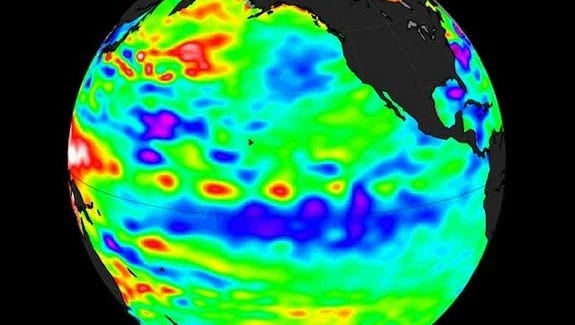
La Niña– a natural cycle marked by cooler-than-average seawater in the central Pacific Ocean – is one of the main drivers of weather in the U.S. and around the world, especially during the late fall, winter and early spring.
The Climate Prediction Center, which is part of the National Oceanic and Atmospheric Administration, released the forecast Thursday, officially declaring a "La Niña watch" for the September-November time frame.
So what does this mean for our weather?
La Niña can impact the Atlantic hurricane season by helping make atmospheric conditions more conducive for tropical storms and hurricanes to form in the Atlantic Ocean, and less conducive in the eastern Pacific Ocean, the Climate Prediction Center said.
The Atlantic hurricane season typically peaks in August, September and October.
And, so far, if 2021 is any indicator, it could be an active year for hurricanes: Through the beginning of July, five named storms in the Atlantic have already formed, a new record – breaking the previous record of four set just last year, the National Hurricane Center said.
La Niña can also act to put a damper on rain across much of the Southwest, not good news for a region that's been plagued with excessive heat, drought and wildfires so far this year.
The prediction center said this year's La Niña (translated from Spanish as “little girl”) is likely to persist through the winter. It's the opposite pattern of El Niño (little boy), which features warmer-than-average seawater in the tropical Pacific Ocean.
The entire natural climate cycle is officially known as the El Niño – Southern Oscillation, or ENSO, a see-saw dance of warmer and cooler seawater in the central Pacific Ocean.
ENSO-neutral conditions, sometimes referred to as "La Nada," which occur when seawater temperatures are about average, are forecast to persist through the summer until La Niña takes over later this year, forecasters said.
We just went through a La NIña last winter. "Is it all that unusual to have two La Niña winters back-to-back? Nope!" wrote Tom Di Liberto of NOAA's Climate Program Office in a blog post released Thursday.
"In fact, of the 12 first-year La Niña events, eight were followed by La Niña the next winter, two by neutral, and two by El Niño," Di Liberto wrote. "Honestly, with those numbers, it would have been more surprising if we thought neutral conditions would continue all year."
Although it's several months away yet, a typical La Niña winter in the U.S. brings cold and snow to the Northwest and unusually dry conditions to most of the southern tier of the U.S., according to the prediction center. The Southeast and mid-Atlantic also tend to see warmer-than-average temperatures during a La Niña winter.
(USA Today)

(VAN) Vikas Rambal has quietly built a $5 billion business empire in manufacturing, property and solar, and catapulted onto the Rich List.

(VAN) Available cropland now at less than five percent, according to latest geospatial assessment from FAO and UNOSAT.

(VAN) Alt Carbon has raised $12 million in a seed round as it plans to scale its carbon dioxide removal work in the South Asian nation.

(VAN) Attempts to bring down the price of the Japanese staple have had little effect amid a cost-of-living crisis.

(VAN) Fourth most important food crop in peril as Latin America and Caribbean suffer from slow-onset climate disaster.

(VAN) Shifting market dynamics and the noise around new legislation has propelled Trouw Nutrition’s research around early life nutrition in poultry. Today, it continues to be a key area of research.

(VAN) India is concerned about its food security and the livelihoods of its farmers if more US food imports are allowed.